
Wonders of Canada
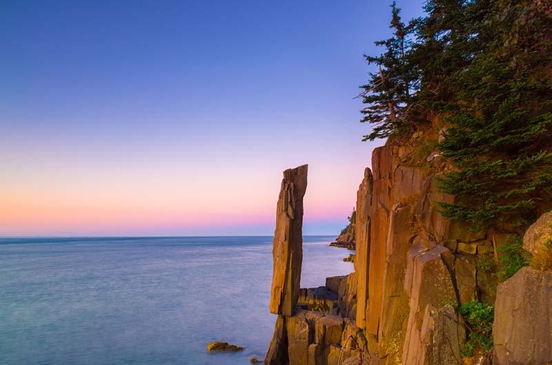
Balancing Rock - Nova Scotia
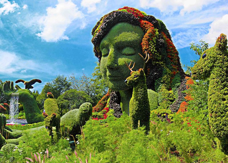
On its 75 hectares, the Montréal Botanical Garden presents a remarkably diverse array of plants to visitors in all seasons
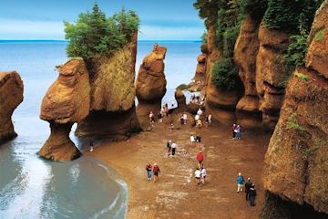
Bay Of Fundy
Located on the east coast of Canada, the Bay of Fundy provides the ideal backdrop of an abundance of nature, historic and adventure activities. The Bay of Fundy is an ocean bay stretching between the provinces of New Brunswick and Nova Scotia. It has the highest tides in the world and it's estimated that 100 billion tonnes of seawater flows in and out at each tide cycle.
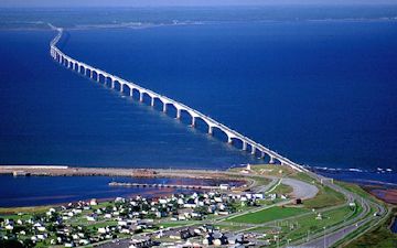
Confederation Bridge
The Confederation Bridge spans the Abegweit Passage of Northumberland Strait, linking Prince Edward Island with mainland New Brunswick
The Confederation Bridge consists of three parts:
The West Approach Bridge leaves Jourimain Island, New Brunswick and is 1.3 km over 14 piers.
The East Approach Bridge leaves Borden-Carleton, Prince Edward Island and is 0.6 km over seven piers.
The Main Bridge is 11.0 km and joins the approach bridges, resting on 44 piers.
The Bridge's highest point is located at the Navigation Span - 60 meters above water. This allows for the movement of larger sea-faring vessels under the bridge.
Additional information: Confederation Bridge
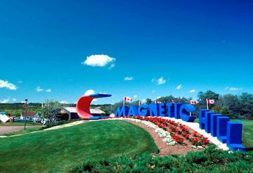
Magnetic Hill New Brunswick is a wild and wacky place that appears to defy gravity. For years now, people have been entertained by driving their car to the bottom of the hill, putting the car in neutral and watching as their car rolls backwards, with them in it, UP the hill! In the 1800s, farmers were puzzled when it seemed that their horses had to strain to pull wagons that were seemingly going downhill; then on the way home, the wagons seemed to get tangled up with the horses' feet while going uphill. How was any of this possible? People thought perhaps there was a powerful magnet buried at the top of the hill which pulled objects to it. Actually, it's a common illusion where the level horizon is hidden in some way. Trees, walls and things that normally act as a visual clue may be leaning slightly. We expect such things to be straight and so we are fooled. An optical illusion makes a downhill appear to be an uphill. But seeing is believing, so even when you know the cause, you still can't help but think that when you're rolling uphill, you're actually rolling downhill. Freaky!
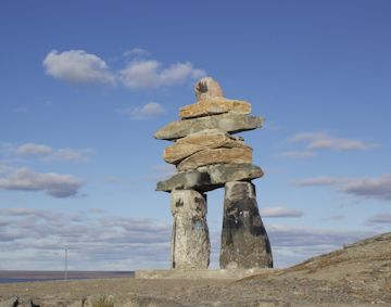
Rankin Inlet Inuksuk
The Inuksuk is a symbol with deep roots in the Inuit culture, a directional marker that signifies safety, hope and friendship. The word inuksuk means "something which acts for or performs the function of a person." Rankin Inlet inuksuk is a classic example of this remarkable symbol. *
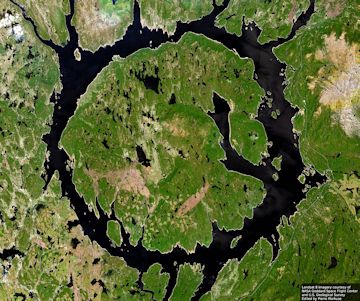
The Manicouagan Crater in northern Quebec is one of the oldest impact craters known. Formed during a tremendous impact about 200 million years ago, the present day terrain supports a 70-kilometer diameter hydroelectric reservoir in the telltale form of an annular lake. The crater itself has been worn away by the passing of glaciers and other erosional processes. Still, the hard rock at the impact site has preserved much of the complex impact structure and so allows scientists a leading case to help understand large impact features on Earth and other Solar System bodies. Also visible above is the vertical fin of the Space Shuttle Columbia from which the picture was taken in 1983.
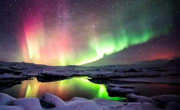
Northern Lights
The Northern Lights have had a number of names throughout history. The scientific name for the phenomena is Aurora Borealis, which is Latin and translates into the red dawn of the north.
The Northern Lights are a result of our atmosphere shielding against solar particles which would otherwise make our planet uninhabitable.
To read more about them: Northern Lights
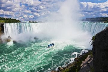
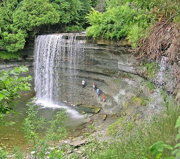
Niagara Falls is a set of massive waterfalls located on the Niagara River, on the border between Canada and the United States. The Falls are comprised of three separate waterfalls: the Horseshoe Falls, the American Falls, and the smaller, adjacent Bridal Veil Falls.
For additional information: Niagara Falls A short distance from the wineries of The Niagara Peninsula
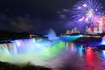
Niagara Falls photographed at night
To see the wineries of the Niagara Peninsula click here.
Canada's national parks system the world's oldest was created one century ago this year with Banff, Yoho, Glacier, Waterton Lakes, St Lawrence Islands, and Jasper the first members (Banff itself became a park 126 years ago). More than just a place to go camping, Canada's national parks and national historic sites are some of the world's most sought-after travel destinations.
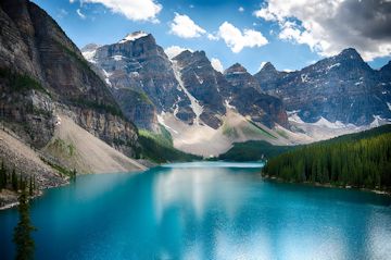
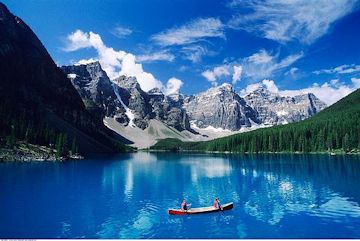
Moraine Lake in Banff National Park
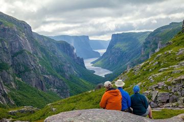
Gros Morne National Park of Canada was designated a UNESCO World Heritage Site in 1987. It is an area of great natural beauty with a rich variety of s scenery, wildlife, and recreational activities. Visitors can hike through wild, uninhabited mountains and camp by the sea. Boat tours bring visitors under the towering cliffs of a freshwater fjord carved out by glaciers. Waterfalls, marine inlets, sea stacks, sandy beaches, and colourful nearby fishing villages complete the phenomenal natural and cultural surroundings of Gros Morne National Park of Canada.
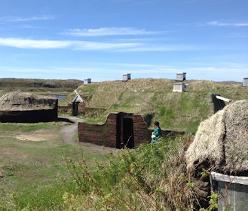
Viking longhouses and the original summerhouse Location: L'Anse aux Meadows National Historic Site/UNESCO World Heritage Site Region: Newfoundland's Northern Peninsula
Manitoulin Island is the world's largest freshwater lake island. With an area of 2,766 km² (1,068 square miles ), it is the 174th largest island in the world , and Canada's 31st largest island. Part of Ontario the island separates the larger part of Lake Huron to its south and west from Georgian Bay to its east and the North Channel to the north. Manitoulin Island itself has 108 freshwater lakes, some of which have their own islands; in turn a few of these "islands within islands" have their own ponds. Lake Manitou (about 104 km²) is the largest lake in a freshwater island in the world. The island has three rivers, the Kagawong, Manitou, and Mindemoya Rivers , which provide spawning grounds for Atlantic Salmon and trout
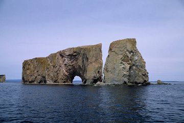
Percé Rock(or Rocher Percé) is a monolith off the Gaspe' Peninsula , 750 km east of Québec City, near its namesake, the town of PERCÉ . This limestone island-peninsula, once attached to the shoreline, is of an impressive size: 450 m long, 90 m wide and 85 m high. It can be reached at low tide. Its name is derived from the fact that the sea has pierced holes in its structure to form archways. According to some, there were once 4 arches, but only one large opening, 30 m wide, exists today. It is known that one arch eroded in 1845, leaving the pillar known as L'Obelisque. Enigmatic and fascinating, immortalized by artists, poets and writers, Rocher Percé is one of the major tourist attractions of Québec and Canada, and is an important Bird Sanctuary.
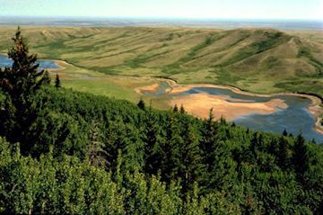
The Cypress Hills have been nourishing bodies and souls for centuries. Native tribes of the plains came to these pine-crested highlands to share the bountiful resources and participate in key spiritual ceremonies. Today's visitors play and relax in a striking park that honours its heritage by disregarding the Saskatchewan-Alberta boundary it spans. Cypress Hills Inter-provincial Park is the first and only inter-provincial park in Canada
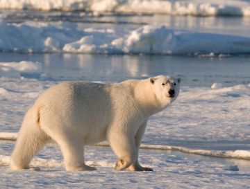
Polar Bears
Churchill, Manitoba, is known as the "Polar Bear Capital of the World." In October and early November, polar bears congregate at nearby Cape Churchill in large numbers, waiting for the ice to form on Hudson Bay. Once the ice is stable enough, they disperse to spend the winter hunting seals. In these two short months you have the chance at seeing these mighty creatures up close from the comfort and safety of a specially-designed vehicle called the Tundra Buggy. It's a once in a lifetime opportunity and a must for wildlife enthusiasts
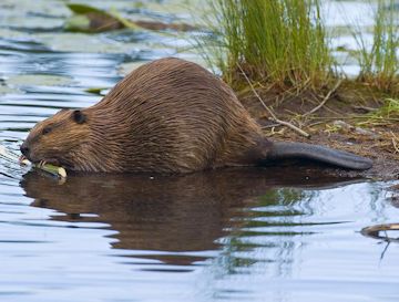
The Beaver is the National Animal of Canada. The search for the beaver's pelt lead to the exportation of Canada. After the early European explorers realized that Canada was not the spice-rich Orient, the main mercantile attraction was the beaver, then a population numbering in the millions. In the late 1600s and early 1700s, the fashion of the day demanded fur top-hats, which needed beaver pelts. As these hats became more popular, the demand for the pelts grew. Explorers were dispatched deep into the North American wilderness to trap and trade for furs with local natives
Beautiful, Magnificent Canadian Rockies
The Canadian Rockies are distinct from the American Rockies in that they are older mountains. They even look different, as the Canadian Rockies have been been very heavily glaciated, resulting in sharply pointed mountains separated by wide, U-shaped valleys gouged by glaciers, whereas the American Rockies are more rounded
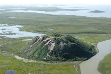
A Pingo is a geological phenomenon caused by the expansion of underground ice. Pingo's only grow in a permafrost environment and can reach heights of 150 feet making them a prominent landscape feature. They are found in shallow or drained lakes and are believed to have grown as the result of the penetration of permafrost into the thawed lake basin.
Nearly 1400 Pingos, the world's highest concentration, are located on the Tuktoyaktuk Peninsula Northwest Territories along with Ibyuk Pingo, the second highest Pingo in the world.
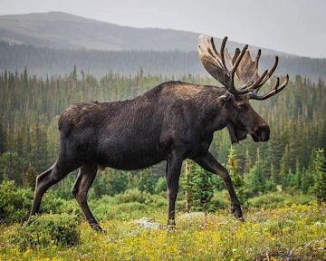
Moose are the largest members of the deer family and typically eat more than nine pounds of vegetation a day -- the equivalent of more than 20,000 leaves The females are smaller, rarely reaching 1000 lbs. The antlers of the moose can reach a span of 6', though they are usually smaller. Their coats are dark brown to black.
Swamps and lakes are a favorite place for the moose, where they feed on aquatic vegitation as well as shoots of willows, maples, and birches. In the summer they are usually solitary but during winter months they often gather in herds. Their long legs allow them to travel through deep snow and swamps that other animals cannot navigate.
Moose are most active at dawn and dusk, but can be spotted throughout the day. There are several famous mud bogs along the Kanc, Rt 118 and Rt 16 near Errol that often have moose at dusk or dawn. They are not very afraid of humans, since they have no natural predators in the region. Mothers are protective of their calves and will charge if they feel the calf is threatened.
Home | Sitemap | Gallery | Maps | Canada |Contact Us |©2020 Robert A Bell